
Image Details
Courtesy Alfonso Archi
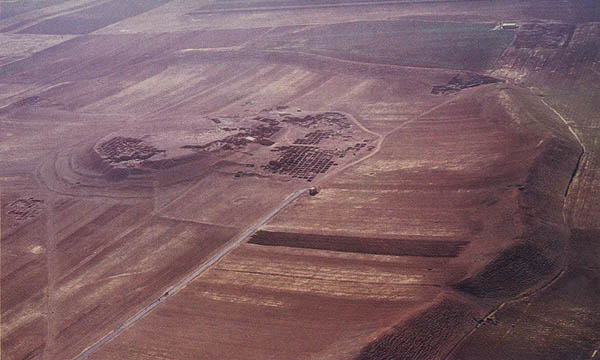
Ancient Ebla, known today in Arabic as Tell Mardikh (shown here, compare with previous photo), rises more than 100 feet above the neighboring watermelon fields and covers about 140 acres. Some idea of Ebla’s size may be gained from this photo by comparing its massive ramparts, which curve around from lower right to upper left, with the road that crosses the site from lower left to upper right. Located in Syria, about 34 miles south of Aleppo (see map), Ebla had an estimated population of 10,000 to 20,000 persons at its height (about 2400–2250 B.C.), when it served as a major commercial center. After its destruction, probably at the hands of invaders from southern Mesopotamia, Ebla rose again and underwent a period of extensive building of palaces and temples (1900–1800 B.C.), but was finally destroyed by the Hittites in about 1600 B.C. Small settlements occupied the site in later years.
Excavation of the mound began in 1964 and included much digging on the acropolis (the high ground at left of center in this photo), the site of several palaces and temples. In Royal Palace G, on the western side of the acropolis, a huge archive of inscribed tablets (see photos of the great archive) came to light in 1975. This alone would have been cause for joy, but claims that the tables bore the names of biblical cities and people, the name of Yahweh and an apparent parallel to the biblical creation story fired the popular imagination and focused worldwide attention on the discovery.
In the accompanying article, scholar Alan Millard examines the claims and reassesses the significance of Ebla for biblical studies.