
Image Details
Leen Ritmeyer
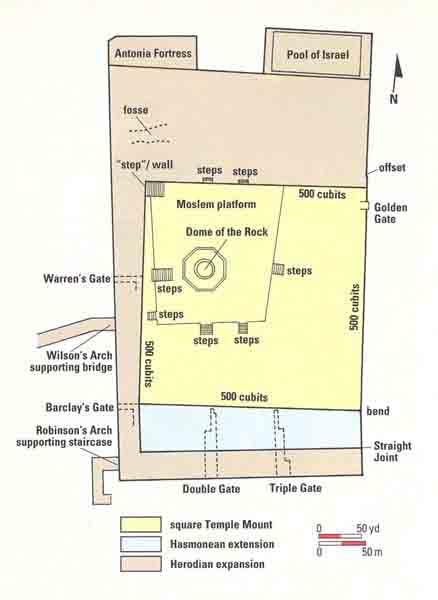
Where was the temple? This plan shows the Temple Mount as expanded by Herod to hold his lavishly rebuilt Second Temple. Highlighted in yellow is the square Temple Mount that supported the First Temple. In a previous article, Ritmeyer established the location of the square Mount, thanks to a telltale “step” on the northwest corner of the present-day Moslem platform. Ritmeyer noticed that the stairway was parallel to the eastern wall of the Temple Mount and not, like the seven other stairways, to the Moslem platform. He further noticed that the bottom step of this stairway was not really a step but a line of pre-Herodian stones, leading him to wonder whether it was actually part of an early wall. His hunch was confirmed when he discovered that the distance from this bottom “step” to the eastern wall was 500 royal cubits—the distance given in the Mishnah (an early compendium of rabbinic law) for the sides of the square Temple Mount. From this newly ascertained northeast corner, it is another 500 cubits to a bend in the eastern wall, which marks the beginning of a southern addition to the square Temple Mount.
Two criteria allowed Ritmeyer then to determine that the Temple had stood on the area now occupied by the Dome of the Rock. First, the location is the highest point on the Mount and, second, it matches a description given by the Mishnah for the Temple: The largest open space on the Temple Mount, according to the Mishnah, was on the south, the second on the east, the third on the north and the least on the west. Having identified the square Temple Mount and the location of the Temple, Ritmeyer was left with one last challenge: Could he pinpoint the Holy of Holies—and perhaps the spot where the Ark of the Covenant stood?