
Image Details
Courtesy Harvard Semitic Museum
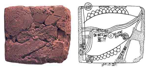
The oldest known map was inscribed on this clay tablet sometime between 2360 and 2150 B.C. As was customary with ancient maps, this map is oriented with east at the top.
The drawing helps to identify the features on the map. The humps represent mountains; a river (called the “fructifier”) runs through the center of the map. Scholars are not certain precisely what area the map represents. One interpretation is that the circles indicate cities, but the Old Akkadian cuneiform writing identifying the cities is illegible except for the writing in the circle in the lower left corner of the map; this may be read as Ebla, meaning the city itself or a fortress belonging to the city of Ebla.
This map was found in 1931 at Nuzi, a site in northeast Iraq about 400 miles east of Ebla.