
Image Details
Werner Braun
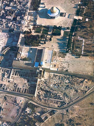
The Old City of Jerusalem: We are looking toward the north, as on a map. The great rectangular walled platform of the Temple Mount, which was enlarged by Herod the Great on the site of King Solomon’s Temple, rises adjacent to the eastern wall of the Old City of Jerusalem. In the center of the Temple Mount is the golden Dome of the Rock. Below it, on the southern end of the Temple Mount, is the silver dome of the El-Aksa mosque. To the south and west of the Temple Mount we see the Temple Mount excavations which, since 1967, have been directed by Professor Benjamin Mazar of the Hebrew University of Jerusalem. The monumental first century A.D. staircase which led up to the main entrance of the Temple compound from the South in Herodian times is visible below (south of) and to the right of the silver dome of the El-Aksa mosque. West of the Temple Mount (and north of the excavations in the shadow) is a large open plaza dotted with groups of people. The portion of Temple Mount retaining wall which borders this plaza on the east is the Wailing or Western Wall, a portion of Herod’s original wall where Jews come to pray and remember the Temple that once stood above it on the Mount. West of this plaza are the crowded houses in the walled Old City.
South of the Temple Mount excavations, below the lower edge of this picture, extends the narrow spur where the original Jerusalem, known even today as the City of David, was located. On this small rocky hill, near the Spring Gihon, the first Jerusalem began in about 3000 B.C. Later this small spur became the capital of King David’s kingdom. New excavations in the City of David are uncovering exciting remains from Israelite and Herodian Jerusalem. (See “Digging in the City of David.”)