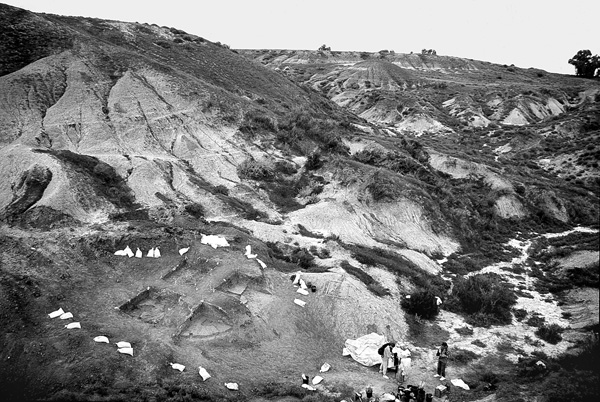
The Lower Paleolithic site of Biẓat Ruḥama (Ruḥama Swamp), located in the Coastal Plain of the northern Negev, was first described following the survey conducted in 1977 by M. Lamdan and others, and excavated in 1996 by A. Ronen of the University of Haifa and J. M. Burdukiewicz of the University of Wroclaw.
EXCAVATION RESULTS
The stratigraphy of the site is comprised of the following layers, from top to bottom:
A. Yellowish loess, 1–2 m thick.
B. Brown clay, c. 10 m thick.
C. A dark gray hydromorphic clay, 1–3 m thick, with small iron-manganese concretions indicating humid conditions.
C1. Finely laminated silty sand, 20–30 cm thick. This layer contains the archaeological horizon of Biẓat Ruḥama.
D. A reddish sandy loam (ḥamra soil), 2–3 m thick.
E. Sandstone.
This stratigraphy reflects a gradual onset of wet conditions in the area. Human occupation took place during the initial stage of the wet conditions, during the accumulation of layer C1. This thin habitation layer probably reflects a single occupation. The finds include numerous flint artifacts (c. 1,200 specimens recovered from c. 10 sq m), pebbles, and a few well-preserved animal bones and shells. Later, when hydromorphic conditions fully developed, the site was covered by the quasi-sterile dark clay of layer C and occupation ceased.
The date of the Biẓat Ruḥama site is based on radiothermoluminescence (RTL) and paleomagnetic studies. The RTL dates are 480,000±120,000 years for layer C; 740,000±180,000 years for the archaeological layer C1; and 840,000±200 years for layer D. Paleomagnetic measurements in layers B, C, C1, and D indicate a reversed polarity for all of them. Based on this data, the age of 990,000–850,000 years, between the Jaramillo episode and the Brunhes–Matuyama boundary, has been suggested by S. A. Laukhin and others for the archaeological horizon. Similar results were obtained independently by H. Ron and G. Gvirtzman, who carried out paleomagnetic analysis of layers C1 and D. These layers showed reversed polarity; hence, the archaeological horizon at Biẓat Ruḥama is dated to around 1,000,000 years ago.
The lithic industry of Biẓat Ruḥama utilized pebbles exclusively, as the high-quality flint preferred by the inhabitants of the site occurs only in small pebbles with an average length of around 40 mm. The lithic assemblage is unique in the very small size of its tools, flakes, and cores (average 25 mm), which are simply too small to be hand-held for use. The remote age notwithstanding, the possibility that the Biẓat Ruḥama artifacts were hafted should be seriously considered. The reduction sequence was well organized in all stages, from the selection of raw material, through the production of desired blanks, to the shaping of tools. Thick blanks were preferred.
The average size of flakes at Biẓat Ruḥama is c. 20 by 18 by 9 mm. The width/thickness ratio is 2:1.8, by far the lowest among Lower Paleolithic industries in the Levant. All the tools are unifacial, apart from two small bifacial points. The dominant tool type is a thick, crude point (c. 40 percent of the assemblage), followed by sidescrapers/retouched items (29 percent), and denticulates/notches (23 percent). Limestone artifacts are entirely absent at the site, in contrast to other roughly contemporary sites such as ‘Ubeidiya, Gesher Benot Ya‘aqov, and Latamne.
In summary, the archaeological site of Biẓat Ruḥama is among the most ancient sites of the Levant, and the oldest of the “small-tool” Lower Paleolithic sites known in Asia and Europe.
AVRAHAM RONEN
Main publication: Y. Zaidner, The Lithic Assemblage of Bizat Ruhama: Lower Paleolithic Site in Southern Coastal Plain, Israel (M.A. thesis), Haifa 2003 (Eng. abstract).
Studies: J. D. Clark, Quaternaria 10 (1969), 1–73; M. Y. Ohel, TA 3 (1976), 49–56; M. Lamdan et al., Prehistoric Archaeological Survey ofNaḥalShiqma, Sha‘ar Ha-Negev 1977; A. Jelinek, Préhistoire du Levant (Colloques Internationaux du Centre National de la Recherche Scientifique 598), Paris 1981, 265–280; O. Bar-Yosef & N. Goren-Inbar, The Lithic Assemblages of ‘Ubeidiya (Qedem 34), Jerusalem 1993; A. Belfer-Cohen & N. Goren-Inbar, World Archaeology 26 (1994), 144–157; A. Ronen et al., Archäologisches Korrespondenzblatt 28 (1998), 163–173; S. A. Laukhin et al., Paléorient 27/1 (2001), 69–80; H. Ron & G. Gvirtzman, Annual Meeting of the Israel Geological Society (eds. Z. Gvirtzman & R. Amit), Eilat 2001, 95; Y. Zaidner, L’Anthropologie 107 (2003), 203–222; id., Lower Palaeolithic Small Tools in Europe and the Levant (BAR/IS; eds. J. M. Burdukiewicz & A. Ronen), Oxford 2003, 121–131.
EXCAVATION
The Lower Paleolithic site of Biẓat Ruḥama (Ruḥama Swamp), located in the Coastal Plain of the northern Negev, was first described following the survey conducted in 1977 by M. Lamdan and others, and excavated in 1996 by A. Ronen of the University of Haifa and J. M. Burdukiewicz of the University of Wroclaw.
EXCAVATION RESULTS
The stratigraphy of the site is comprised of the following layers, from top to bottom: